
তেঁতুলিয়া উপজেলা - Tetulia Upazila
তেঁতুলিয়া পঞ্চগড় জেলার অন্তর্গত বাংলাদেশের সর্বউত্তরের উপজেলা। গৌরবান্বিত ইতিহাস, বিশ্বনন্দিত অর্গানিক চা, চতুর্দেশীয় বাংলাবান্ধা স্থলবন্দর এবং পর্যটন শিল্পের কারণে তেঁতুলিয়া উপজেলা সুবিখ্যাত। ঐতিহাসিক তেঁতুলিয়া উপজেলা বাংলাদেশের প্রাচীনতম থানারগুলোর মধ্যে অন্যতম।
নামকরণঃ তেঁতুলিয়া নামকরণের ইতিহাস ও উৎপত্তিকালের দালিলিক প্রমাণ পাওয়া যায়নি। জনাব ড.নাজমুল হক রচিত ‘পঞ্চগড়: ইতিহাস ও লোক ঐতিহ্য’ গ্রন্থে প্রদত্ত তথ্যে জানা যায়, অতীতে কোচবিহারের রাজা যেসব প্রজা খাজনা দিতে পারতো না তাঁদেরকে এই স্থানের তেঁতুল গাছের তলায় বেঁধে মারধর করতেন। অন্য মতে, খাজনা দিতে অক্ষম প্রজাদের নিকট হতে টাকার পরিবর্তে প্রতীকী খাজনাস্বরূপ তেঁতুলের বীজ গ্রহণ করা হতো। অনেকের ধারণা কোচবিহারের মহারাণী তেঁতুল পছন্দ করতেন। রাজার নির্দেশে প্রজারা নিয়ে আসতো অজস্র তেঁতুল। রাণী খুশি হয়ে মওকুফ করে দিতেন সেই সব প্রজার খাজনা। অপরদিকে জনশ্রুতি রয়েছে, ডাকবাংলোর উঁচু টিলার উপর বাস করতেন একজন বিশিষ্ট বণিক। তাঁর বাবার নাম ছিল ‘টিটু’। সেই বণিকের বাবার নাম ‘টিটু’ অথবা ‘তেঁতুল’ থেকে এই জনপদের নামকরণ ‘তেঁতুলিয়া’ হতে পারে বলে প্রচলিত লৌকিক গল্প হতে জানা যায়। তবে স্থানীয়ভাবে এটাও ধারণা করা হয় যে, তেঁতুলিয়া উপজেলা শহরে অবস্থিত একটি তেঁতুল গাছের কারণে তেঁতুলিয়া নামকরণ করা হয়। সর্ব উত্তরের একটি উপজেলা হিসেবে পরিচিত থাকলেও নামকরণের জন্য পর্যটকসহ নতুন প্রজন্মের কাছে বেশ পরিচিত প্রাচীন সেই তেঁতুল গাছ।
ভৌগোলিক অবস্থান ও আয়তনঃ তেঁতুলিয়া উপজেলা তিন দিক থেকে ভারতীয় সীমান্ত দ্বারা বেষ্টিত। তেঁতুলিয়া উপজেলা ২৬°২৪´ থেকে ২৬°৩৮´ উত্তর অক্ষাংশ এবং ৮৮°২১´ থেকে ৮৮°৩৩´ পূর্ব দ্রাঘিমাংশ স্থানাঙ্কে অবস্থিত। উপজেলার উত্তরে ভারতের দার্জিলিং ও শিলিগুড়ি, উত্তর পূর্ব এবং পূর্বে জলপাইগুড়ি ও কোচবিহার জেলা, পশ্চিমে ভারতের পূর্ণিয়া, উত্তর দিনাজপুর এবং দক্ষিণ ও দক্ষিণ পূর্বে পঞ্চগড় সদর অবস্থিত। তেঁতুলিয়া উপজেলার আয়তন ১৮৯.১২ বর্গ কিমি বা ৭৩ বর্গ মাইল। তেঁতুলিয়া উপজেলার সাথে ভারতের সীমান্ত প্রায় ৯০ কিমি বা ৫৬ মাইল দীর্ঘ্য।
প্রশাসনিক এলাকাঃ সুপ্রাচীন ইতিহাস এবং ভৌগোলিক অবস্থানগত কারণে তেঁতুলিয়া পঞ্চগড় জেলার সবচেয়ে গুরুত্বপূর্ণ উপজেলা। তেঁতুলিয়া উপজেলা ৭ টি ইউনিয়ন, ৩৩ টি মহল্লা/মৌজা এবং ২৪৬ টি গ্রাম নিয়ে গঠিত। এছাড়া তেঁতুলিয়ায় উপজেলা প্রশাসন ভবন, পুলিশ স্টেশন ও উপজেলা হাসপাতাল রয়েছে। তেঁতুলিয়া উপজেলার ৭ টি ইউনিয়নের নামঃ
(১) বাংলাবান্ধা ইউনিয়ন
(২) তিরনইহাট ইউনিয়ন
(৩) তেঁতুলিয়া ইউনিয়ন
(৪) শালবাহান ইউনিয়ন
(৫) বুড়াবুড়ি ইউনিয়ন
(৬) ভজনপুর ইউনিয়ন
(৭) দেবনগড় ইউনিয়ন
জনসংখ্যাঃ ২০১১ এর আদমশুমারি তথ্য অনুসারে তেঁতুলিয়ার জনসংখ্যা ছিল মোট ১৬০০৯০ জন। যার মধ্যে নারী ৭৯৯২৪ জন এবং পুরুষ ৮০১৬৬ জন। তেঁতুলিয়া উপজেলায় ক্ষুদ্র নৃ-গোষ্ঠীর অন্তর্গত ২ টি সম্প্রদায়ের লোক বাস করে। সম্প্রদায় দুটি হলো সাঁওতাল ও ওঁরাও। এই দুই সম্প্রদায়ের লোকসংখ্যা আনুমানিক ২০০ জন। তাঁদের অধিকাংশই খ্রিস্টান ধর্মে দীক্ষিত। তেঁতুলিয়া সদর ইউনিয়নের দর্জিপাড়া ও ভাদ্রবাড়ী গ্রাম, তিরনইহাট ইউনিয়নের ইসলামপুর এবং শালবাহান ইউনিয়নের ডাহুক গুচ্ছগ্রামে এ সকল ক্ষুদ্র নৃ-গোষ্ঠীর সম্প্রদায়ের পরিবারবর্গ বসবাস করেন। বুড়াবুড়ি ও শালবাহান ইউনিয়নের মধ্যবর্তী স্থান দিয়ে প্রবাহিত ডাহুক নদীর তীরে মাননীয় প্রধানমন্ত্রীর কার্যালয়ের আশ্রয়ণ-২ প্রকল্পের আওতায় নৃ-তাত্বিক জনগোষ্ঠীদের নিয়ে একটি আশ্রয়ণ গ্রাম প্রতিষ্ঠা করা হয়েছে এবং ক্ষুদ্র নৃ-গোষ্ঠীর শতভাগ পরিবারকে একক গৃহ প্রদানের মাধ্যমে পুনর্বাসন করে ভূমিহীন ও গৃহহীন মুক্ত করা হয়েছে।
উল্লেখযোগ্য শিক্ষা প্রতিষ্ঠানঃ
(ক) তেঁতুলিয়া সরকারি ডিগ্রি কলেজ (১৯৮৬)
(খ) তেঁতুলিয়া সরকারি পাইলট উচ্চ বিদ্যালয় (১৯৫৯)
(গ) ভজনপুর ডিগ্রি কলেজ (১৯৮৭)
(ঘ) বেগম খলেদা জিয়া বালিকা উচ্চ বিদ্যালয়, ভজনপুর
(ঙ) বেগম ফখরুননেছা ফাজিল মাদ্রাসা (১৯৭৮)
(চ) কালন্দিগঞ্জ সিনিয়র মাদ্রাসা (১৯৭৬)
(ছ) কাজী শাহাবুদ্দিন গার্লস স্কুল এন্ড কলেজ (১৯৬৫)
(জ) তেঁতুলিয়া কারিগরি মহাবিদ্যালয় (২০০৪)
(ঝ) হারাদীঘি দ্বিমুখী উচ্চ বিদ্যালয় (১৯৬৯)
(ঞ) মাঝিপাড়া দ্বিমুখী উচ্চ বিদ্যালয় (১৯৭৩)
(ঞ) শালবাহান দ্বিমুখী উচ্চ বিদ্যালয় (১৯৬২)
(ট) ভজনপুর দ্বিমুখী উচ্চ বিদ্যালয় (১৯৫৬)
(ঠ) বোদা ময়নাগুড়ি দ্বিমুখী উচ্চ বিদ্যালয় (১৯১৭)
ইতিহাসঃ তেঁতুলিয়ার সুপ্রাচীন ইতিহাস অত্যন্ত তাৎপর্যপূর্ণ ও গৌরবের। ১৮১৬ খ্রিস্টাব্দ থেকে ১৮২৮ খ্রিস্টাব্দের মধ্যে তেঁতুলিয়ায় ছিল একটি ক্যান্টনমেন্ট। ১৮৭৬ খ্রিস্টাব্দে পরিত্যক্ত সেই ক্যান্টনমেন্টটি বৃটিশ সৈনিকদের ক্যাম্প হিসেবে ব্যবহৃত হয়। তেঁতুলিয়া শহরের পাশেই পুরানো পল্টন নামক স্থানে ব্রিটিশ সৈনিকদের একটি সমাধিস্থল রয়েছে। পঞ্চগড় জেলার তেঁতুলিয়া উপজেলা ১৮৬০ সাল হতে ১৮৬৯ সাল পর্যন্ত রংপুর জেলার একটি মহুকুমা হিসেবে প্রশাসনিক ইউনিটের মর্যাদা লাভ করে। শিল্প, বাণিজ্য ও নদী বন্দর হিসেবে তেঁতুলিয়া ছিল সুবিখ্যাত। মারওয়ারিদের এখানে ছিল একটি প্রধান ব্যবসা কেন্দ্র। মহানন্দা নদী দিয়ে আসা যাওয়া করত মহাজনী নৌকা। এখানে বাণিজ্য মেলা বসত। এ সময়ে তেঁতুলিয়া শহরের গুরুত্ব বৃদ্ধি পায়। তেঁতুলিয়াতে গড়ে উঠে বিশ কিছু চমৎকার পাকা বাড়ী, মন্দির ও একটি ঘোড় দৌড়ের মাঠ। একই সময়ে ম্যালেরিয়া এবং কালা জ্বরে এখানে ব্যাপক প্রাণহানী ঘটে ফলে শহর হিসেবে গড়ে উঠা তেঁতুলিয়া বন্দর নগরটি হয়ে পরে অস্বাস্থ্যকর এবং জনশুন্য। অবশেষে ১৮৭০ সালের ১ এপ্রিল তারিখে এক গেজেট নোটিফিকেশন এর মাধ্যমে তেঁতুলিয়া মহুকুমার সকল ক্ষমতা বিলুপ্ত করে চুড়ান্তভাবে ক্ষমতা হস্তান্তর করা হয় জলপাইগুড়ি জেলার কালেক্টরের হাতে। এর ফলে বিলুপ্ত হয় তেঁতুলিয়ার প্রশাসনিক ক্ষমতা । ১৯১১-১২ সালে তেঁতুলিয়া পূনরায় স্থাপিত হয় একটি পুর্নাঙ্গ পুলিশ স্টেশন বা থানায়। এরপর থেকে ১৯৪৭ সালে ভারত বিভাগের সময় পর্যন্ত তেঁতুলিয়া ছিল জলপাইগুড়ি জেলার অবিচ্ছিন্ন গুরত্বপুর্ন অংশ । ১৯৪৭ সালের ১৮ আগস্ট স্যার রেডক্লিপ ভারতের জলপাইগুড়ি জেলার অন্য ৪ টি থানার সংগে তেঁতুলিয়াকে পূর্ব পাকিস্তানের দিনাজপুরের সাথে যুক্ত করে দেন । ১৯১৭ সালের ২৬ জুন তেঁতুলিয়া থানা গঠিত হয় এবং ১৯৯৩ সালের ১৬ মার্চ থানাকে উপজেলায় রূপান্তর করা হয়।
১৯৭১-এর মুক্তিযুদ্ধে তেঁতুলিয়াঃ মুক্তিযুদ্ধে তেঁতুলিয়া ছিল ৬ নম্বর সেক্টরের অধীন। ঐ সময় বাংলাদেশে যে কয়েকটি অঞ্চল মুক্ত ছিল তারমধ্যে তেঁতুলিয়া অন্যতম। বেশিরভাগ এলাকা সমুহে পাকিস্তানি খান সেনারা আংশিক হলেও দখল করেছিল বা সাময়িকভাবে দখলে নিয়েছিল। কিন্তু পঞ্চগড় থেকে তেঁতুলিয়াগামী মহাসড়কের অমরখানা এলাকা দিয়ে প্রবাহিত চাওয়াই নদীর (ভারত ও বাংলাদেশ আন্তঃসীমান্ত) ওপর নির্মিত সেতুটি (অমরখানা ব্রীজ নামে পরিচিত) ডায়নামাইট দিয়ে উড়িয়ে দেওয়ায় পাকবাহিনী তেঁতুলিয়ায় প্রবেশ করতে পারেনি। ফলে, মুক্তিযুদ্ধের পুরো সময়টা তেঁতুলিয়া ছিল সম্পূর্ণ মুক্তাঞ্চল । জেলা প্রশাসনের সহযোগিতায় অমরখানার চাওয়াই নদীর পাশে স্বাধীনতার মুক্তাঞ্চল নামে স্মৃতিস্তম্ভ নির্মাণ করা হয়। এই মুক্তাঞ্চলে গিয়ে কাজ করেছেন অস্থায়ী সরকারের প্রধানমন্ত্রী তাজউদ্দীন আহমদ ও মুক্তিযুদ্ধের সর্বাধিনায়ক জেনারেল এম এ জি ওসমানীসহ প্রবাসী সরকারের অন্য মন্ত্রী ও কর্মকর্তারা। তেঁতুলিয়ার মাটির কোথাও পাক হানাদার বাহিনীর অপবিত্র পা স্পর্শ করেনি। তেঁতুলিয়ার দেবনগর নামক গ্রামে ছিল ৬/এ সাব সেক্টর হেডকোয়ার্টার। একমাত্র তেঁতুলিয়ার শেষ পূর্ব প্রান্তের দেবনগর ও আশেপাশের এলাকা এবং পঞ্চগড় সদরের জাবরী দোয়ার, কনপাড়া, জোত সাহেবু, কামাতপাড়া, ময়নাগুড়ি, মাগুরমারী ইত্যাদি এলাকায় পাক বাহিনীর সাথে মুক্তিবাহিনীর মুক্তিযুদ্ধকালীন সময়ে অবিরত গুলি বিনিময় হয়েছে।
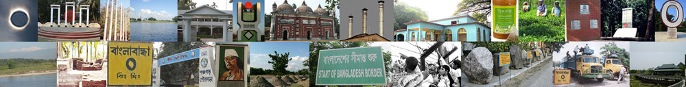
তেঁতুলিয়া ডাকবাংলো ১৯৭১ সালের মহান মুক্তিযুদ্ধের নীরব সাক্ষী। প্রথম দিকে এখানে বসে সভা করতেন মন্ত্রী-কর্মকর্তারা। পরে ডাকবাংলোতে মুক্তিযুদ্ধের ৬ নম্বর সেক্টর কমান্ডার এম কে বাশার বসবাস করতেন। এখানে বসেই ৬ নম্বর সেক্টরের যাবতীয় পরিকল্পনা করতেন মুক্তিযোদ্ধারা। যুদ্ধকালীন সিদ্ধান্ত গ্রহণ আর কর্মকর্তাদের অবস্থানের জন্য নিরাপদ স্থান ছিল তেঁতুলিয়ার ঐতিহাসিক ডাকবাংলো। স্বাধীনতা যুদ্ধে তেঁতুলিয়া ডাকবাংলোর অসাধারণ অবদানের কথা চিরস্মরণীয় করে রাখতে ডাকবাংলো ভবনের পাশে চারকোনা বেদির উপরে একটি স্মৃতিস্তম্ব নির্মাণ করা হয়। স্মৃতিস্তম্বটির নামকরণ করা হয়েছে স্বাধীনতার তীর্থভূমি তেঁতুলিয়া। …তেঁতুলিয়ার মুক্তিযোদ্ধাদের তালিকা | পঞ্চগড়ের শহীদ মুক্তিযোদ্ধাদের তালিকা | মুক্তিযুদ্ধের স্মৃতিসৌধ ও গণকবর
তেঁতুলিয়ার দর্শনীয় স্থানঃ বর্তমান সময়ে পর্যটন নগর খ্যাত তেঁতুলিয়ায় রয়েছে ঐতিহ্যবাহী ডাকবাংলো, তেঁতুলিয়ার তেঁতুলগাছ, পুরাতন থানাসহ বিভিন্ন ঐতিহাসিক স্থাপনা। ঐতিহাসিক স্থাপনাসহ নতুন গড়ে ওঠা পর্যটনকেন্দ্রগুলো সংরক্ষণে এরইমধ্যে বিভিন্ন পদক্ষেপ গ্রহণ করা হয়েছে, নতুন করে সাজানো হয়েছে সব কিছু।
(ক) তেঁতুলিয়া পিকনিক কর্ণার
(খ) তেঁতুলিয়া ডাকবাংলো
(গ) বেরং কমপ্লেক্স
(ঘ) বাংলাবান্ধা জিরো পয়েন্ট
(ঙ) বাংলাবান্ধা স্থলবন্দর
(চ) রওশনপুর আনন্দধারা ও চা বাগান
(ছ) ডাহুক টি রিসোর্ট
(জ) তেঁতুলিয়া পুরাতন থানা ভবন
(ঝ) অপ্রতিরোধ্য বাংলাদেশ
(ঞ) ভদ্রেশ্বর মন্দির (শিব মন্দির)
(ট) বুড়াবুড়ি ইউনিয়নে দুর্গের ভগ্নাংশ
(ঠ) হাতি ফাঁসা বোম
(ড) স্বাধীনতার তীর্থভূমি তেঁতুলিয়া
(ঢ) তেঁতুলিয়া শিব মন্দির
…পঞ্চগড়ের অন্যান্য দর্শনীয় স্থানসমূহ
নদীঃ তেঁতুলিয়া উপজেলার বিখ্যাত নদীর নাম মহানন্দা । ভারত থেকে এ নদীটি তেঁতুলিয়া হয়ে বাংলাদেশে প্রবেশ করেছে । এ নদীর প্রধান বৈশিষ্ট্য এখানে প্রচুর পাথর পাওয়া যায় । তেঁতুলিয়া উপজেলার স্থানীয় মানুষ এ নদী থেকে পাথর উত্তোলণ করে জীবীকা নির্বাহ করে । তেঁতুলিয়া ডাকবাংলোর পাশ দিয়ে প্রবহমান মহানন্দা নদী অত্যন্ত মনোমুলধকর মনোরম ও মনোমুগ্ধকর। হিমালয়ের পাদদেশ হতে উৎপন্ন হয়ে ডাকবাংলো ঘেঁষে বহমান মহানন্দা নদীর অপরপাশে সীমান্তের কাটাঁতারের বেড়া, দৃশ্যমান কাঞ্চনজঙ্ঘা ও ভারতের শিলিগুড়ি।
তেঁতুলিয়ার শালবাহান দিঘী, দেবনগর দিঘী, ঝিলিঙ্গি দীঘি, চাউলখুড়ি দীঘি, সিপাহী দীঘি, কৈমারী পুকুর, লেতারী পুকুর, টিটিহি পুকুর এবং ভূতি পুকুর উল্লেখযোগ্য প্রাচীন পুকুর ও দীঘি। তেঁতুলিয়ার শালবাহান এলাকায় রয়েছে বিস্তীর্ণ তুলশিয়া বিল।
তেঁতুলিয়া উপজেলায় ৯টি নদী রয়েছে।
(১) মহানন্দা নদী
(২) করতোয়া নদী
(৩) ডাহুক নদী
(৪) বেরং নদী
(৫) গোবরা নদী
(৬) তিরনই নদী
(৭) ভেরসা নদী
(৮) সাঁও নদী
(৯) রনচন্ডী নদী
…পঞ্চগড় জেলার নদ-নদী
তেঁতুলিয়ার উল্লেখযোগ্য ব্যক্তিত্বঃ তেঁতুলিয়ার প্রখ্যাত ব্যক্তিদের মধ্যে উল্লেখযোগ্য কয়েকজন হলেনঃ
(ক) জমির উদ্দিন সরকার
(খ) বীর বিক্রম শহীদ সকিম উদ্দীন
(গ) বীর প্রতীক ল্যান্স নায়েক মোঃ আব্দুল মান্নান
(ঘ) সফিকুল আলম চৌধুরী
(ঙ) রোকেয়া বেগম
(চ) রহিম আব্দুর রহিম
(ছ) আবুল হোসেন মণ্ডল
… পঞ্চগড়ের অন্যান্য উল্লেখযোগ্য ব্যক্তিত্ব
স্থানীয় অর্থনীতি ও শিল্প কারখানাঃ তেঁতুলিয়া উপজেলার স্থানীয় জনসাধারণ অধিকাংশই কৃষিনির্ভর জীবিকা নির্ধারণ করে। বিস্তীর্ণ সমতলের চা বাগান, চতুর্দেশীয় বাংলাবান্ধা স্থলবন্দর ও তেঁতুলিয়ার পর্যটন শিল্প পঞ্চগড় জেলার সামগ্রিক অর্থনীতিকে করেছে গতিশীল।
২০১১ সালের সরকারি তথ্য অনুযায়ী তেঁতুলিয়ার স্থানীয় জনগোষ্ঠীর আয়ের প্রধান উৎস কৃষি ৬১.৭২%, অকৃষি শ্রমিক ১৬.০১%, ব্যবসা ৮.৮৪%, পরিবহন ও যোগাযোগ ২.৩৩%, চাকরি ৪.৩৮%, নির্মাণ ০.৪৬%, ধর্মীয় সেবা ০.০৯%, রেন্ট অ্যান্ড রেমিটেন্স ০.০৯% এবং অন্যান্য ৬.০৮%।
(ক) চা উৎপাদন তেঁতুলিয়ার প্রধান শিল্প। তেঁতুলিয়ায় উৎপাদিত অর্গানিক চা বিশ্ব বাজারে ব্যাপক চাহিদা রয়েছে।
(খ) তেঁতুলিয়ার নুড়ি পাথর উত্তোলন এখানকার স্থানীয় অর্থনীতির মূল ভিত্তি।
(গ) তেঁতুলিয়ার প্রধান কৃষিজাত পণ্য ধান, পাট, গম, আখ, আলু, রসুন, শাকসবজি এবং সুপারি।
(ঘ) প্রধান ফল-ফলাদি আম, জাম, কাঁঠাল, লিচু, তরমুজ, পেঁপে, আনারস, কমলা।
(ঙ) প্রাকৃতিক সম্পদ কাঁচবালি, বোল্ডার পাথর, চিপপাথর এবং নুড়িপাথর।
(চ) প্রধান রপ্তানিদ্রব্য অর্গানিক চা, পাথর, তরমুজ, আনারস, কাঁঠাল, পেঁপে, রসুন। তেঁতুলিয়ায় তৈরি টুপি রপ্তানি হয়ে থাকে।
(ছ) তেঁতুলিয়ার কুটিরশিল্প মৃৎশিল্প, তাঁতশিল্প, পাটশিল্প, বাঁশের কাজ।
(ঝ) শালবাহান তেল খনি।
(ঞ) তেঁতুলিয়ার বিলুপ্ত বা বিলুপ্তপ্রায় ফসলাদি কাউন, যব, সরিষা, মিষ্টি আলু, অড়হর, তিসি।
…পঞ্চগড়ের শিল্প ও বাণিজ্য
হাটবাজার ও মেলাঃ তেঁতুলিয়া বাজার, শালবাহান হাট, ভজনপুর হাট, সিপাইপাড়া হাট, তিরনাই হাট, বুড়াবুড়ি হাট, মহুরীর হাট উল্লেখযোগ্য।
যোগাযোগ ব্যবস্থাঃ ভৌগোলিক অবস্থানগত কারণে প্রাচীনকাল হতে স্থল ও নৌপথে তেঁতুলিয়ার যোগাযোগ ব্যবস্থা ছিল বেশ উন্নত। যোগাযোগ ব্যবস্থার উপর ভিত্তি করে শিল্প বাণিজ্য ও নদী বন্দর হিসেবে ধীরে ধীরে তেঁতুলিয়া হয়ে উঠে সুবিখ্যাত। ঐতিহাসিক গুরুত্ব বিবেচনায় পঞ্চগড় জেলার প্রাচীন সড়কগুলোর মধ্যে বিখ্যাত সড়ক হল দার্জিলিং-বর্ধমান রোড (বর্তমানে বাংলাদেশ অংশের তেঁতুলিয়া-বাংলাবান্ধা রোড) । এটি এক সময় গ্যাঞ্জেস-দার্জিলিং রোড নামেও পরিচিত ছিল। ভারতে রেলপথ নির্মাণের পূর্বে এটিই ছিল কলকাতা থেকে দার্জিলিং যাওয়ার অন্যতম প্রধান সড়ক । প্রাচীনকালের এই সড়ক পথ ও নদী বন্দরকে কেন্দ্র করে গড়ে ওঠা বাণিজ্য কেন্দ্র থেকেই ধীরে ধীরে সৃষ্টি হয় তেঁতুলিয়া।
বর্তমানে সড়কপথই তেঁতুলিয়ায় যোগাযোগের একমাত্র মাধ্যম। NH5 বা ঢাকা-বাংলাবান্ধা জাতীয় মহাসড়কটি রাজধানী ঢাকার সাথে তেঁতুলিয়া হয়ে বাংলাবান্ধা স্থলবন্দরকে সংযুক্ত করেছে। এই মহাসড়কের পঞ্চগড়-তেঁতুলিয়া-বাংলাবান্ধা অংশটি ৫৩.১০ কিমি দীর্ঘ। দক্ষিণ এশিয় উপ-আঞ্চলিক অর্থনৈতিক সহযোগিতা (SASEC) সড়কটি এশিয়ান হাইওয়ে-২ রুট নামে তেঁতুলিয়ায় অধিক পরিচিত। এই মহাসড়কটির দুপাশের চা-বাগান, সীমান্তের নদী, শীতকালের কুয়াশাচ্ছন্ন পথ – পর্যটকদের কাছে অন্যতম আকর্ষণ। তেঁতুলিয়ার নিকটতম পঞ্চগড় রেলওয়ে স্টেশন, তেঁতুলিয়া উপজেলা সদর হতে ৪১ কিমি দূরত্বে অবস্থিত। তেঁতুলিয়া-ঢাকা রুটে সরাসরি বাস চলাচল করে। ঢাকা, বগুড়া, রংপুর ও দশমাইল হয়ে পঞ্চগড়-তেঁতুলিয়াগামী বাস ধরে তেঁতুলিয়া আসা যাবে। তেঁতুলিয়া থেকে রাজধানী ঢাকার দূরত্ব ৫৯০ কিমি। তেঁতুলিয়া হতে সৈয়দপুর বিমানবন্দরের দূরত্ব প্রায় ১৩০ কিমি। …Travel Tips | Accommodation | Tourist Spots
তথ্যসূত্রঃ বাংলাদেশ মুক্তিযুদ্ধ জ্ঞানকোষ | মোঃ ওয়ালী উল্লাহ
Last updated: 17 March 2024